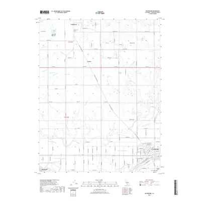
2018 Map of Waterford
USGS Topo · Published 2018About this map
The Tuolumne River winds through the southern reaches of this landscape, defining the geographic orientation of Waterford and the edges of Hughson. This portion of the San Joaquin Valley is shaped by an intricate network of irrigation infrastructure necessary for the region's agricultural output. Numerous water conveyance features, such as the Modesto Lateral Number One, Claribel Lateral, and Lateral Number Eleven, crisscross the terrain between the primary settlements. The town of Claribel sits at a junction of these water routes and the Oakdale Waterford Hwy, while the northern portion of the map transitions toward the outskirts of Oakdale. Local history is visible in the naming of rural routes like Lone Oak Rd and family-named landmarks like Kuhn Drain and Rock Cr Ditch, which reveal the deep connection between private landholdings and the managed water systems of the Central Valley.
Find a feature on this map
105 named features on this map. Tap any name to fly to it.
Don’t see what you’re looking for? This feature index may not catch every label — zoom into the map to look around manually.
Map Details
Editions of this 2018 Waterford Map
This is the sole edition of this map. No revisions or reprints were ever made.
Other maps of this area

1915 · Oakdale
USGS Topo · 1:31,680

1915 · Paulsell
USGS Topo · 1:31,680

1915 · Thalheim
USGS Topo · 1:31,680

1916 · Montpellier
USGS Topo · 1:31,680

1916 · Riverbank
USGS Topo · 1:31,680

1916 · Denair
USGS Topo · 1:31,680

1916 · Waterford
USGS Topo · 1:31,680

1916 · Ceres
USGS Topo · 1:31,680

1916 · Copperopolis
USGS Topo · 1:62,500

1939 · Modesto East
USGS Topo · 1:62,500