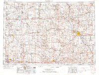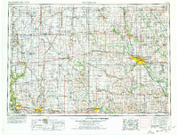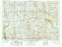
1954 Map of Waterloo
USGS Topo · Published 1973About this map
The confluence of the Cedar River and Black Hawk Creek anchors the primary urban centers of Waterloo and Cedar Falls in this mid-century look at central Iowa. This landscape is defined by its rigorous grid of county roads and a dense concentration of rail lines, including the Illinois Central, Chicago Great Western, and the Waterloo, Cedar Falls & Northern. Further south, the Iowa River cuts through Marshalltown and Eldora, while the western edge of the survey tracks the Des Moines River past Boone. The prominence of Iowa State College in Ames highlights the region's educational and agricultural importance during the 1950s. Smaller communities like Grundy Center, Hampton, and Webster City serve as regional hubs, connected by a maturing highway system that includes U.S. 20 and U.S. 30. The mapping identifies several quarries and gravel pits, indicating the local extraction industries that supported the era's infrastructure growth.
Find a feature on this map
249 named features on this map. Tap any name to fly to it.
Don’t see what you’re looking for? This feature index may not catch every label — zoom into the map to look around manually.
Map Details
Editions of this 1954 Waterloo Map
4 editions found