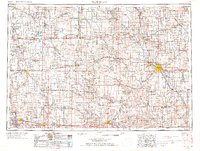
1954 Map of Waterloo
USGS Topo · Published 1968About this map
The Waterloo and Cedar Falls industrial corridor serves as the eastern anchor of this central Iowa landscape, where the Cedar River and Shell Rock River converge. This mid-century survey documents the dense agricultural and transportation lattice that defined the region before the interstate era, centered on the heavy rail networks of the Illinois Central and Chicago and North Western. To the west, the manufacturing hubs of Marshalltown and Ames are clearly delineated alongside the Iowa River, while the western edge reaches the coal-mining history of Boone and the high ground of Pilot Mound. Genealogists will find value in the precise location of rural Cemeteries and numerous small-town rail stops like Jewell, Eldora, and Reinbeck, which supported the surrounding farm economy. The map also traces the winding courses of the Boone River and Wapsipinicon River, showing the natural drainage patterns that shaped early settlement and road placement across several counties.
Find a feature on this map
89 named features on this map. Tap any name to fly to it.
Don’t see what you’re looking for? This feature index may not catch every label — zoom into the map to look around manually.
Map Details
Editions of this 1954 Waterloo Map
4 editions found

Other maps of this area

1888 · Shellsburg
USGS Topo · 1:62,500

1888 · Amana
USGS Topo · 1:62,500

1889 · Amana
USGS Topo · 1:62,500

1889 · Shellsburg
USGS Topo · 1:62,500

1899 · Amana
USGS Topo · 1:62,500

1899 · Shellsburg
USGS Topo · 1:62,500

1901 · Oelwein
USGS Topo · 1:125,000

1903 · Fairfax
USGS Topo · 1:125,000

1903 · Winthrop
USGS Topo · 1:125,000

1906 · Decorah
USGS Topo · 1:125,000