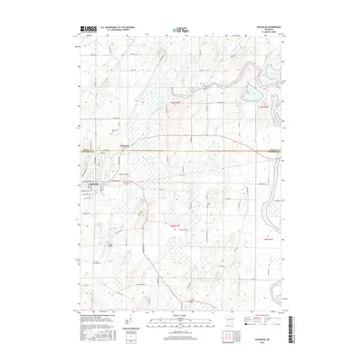
2015 Map of Waterloo
USGS Topo · Published 2015About this map
Waterloo and Portland anchor this landscape where the Maunesha River and Crawfish River converge amidst a complex network of wetlands and small lakes. The terrain is defined by glacial features, with numerous small bodies of water like Chub Lake, Mud Lake, and Mud Cr dotting the northern reaches. This 2015 survey reveals a deeply rooted rural community, evidenced by a high density of family and community burial grounds, including Moravian Cem, Washington Cem, and Oak Hill Cem. The transportation infrastructure is a mix of established county roads like Co RD T and local lanes such as Giese Rd and Hubbleton Rd, which navigate around the marshy bends of Stony Brook. Significant local landmarks like Tesmer Airport highlight the modern utility of the land, while the boundary between Dodge Co and Jefferson Co bisects the area's agricultural and riverine systems.
Find a feature on this map
78 named features on this map. Tap any name to fly to it.
Don’t see what you’re looking for? This feature index may not catch every label — zoom into the map to look around manually.
Map Details
Editions of this 2015 Waterloo Map
This is the sole edition of this map. No revisions or reprints were ever made.
Other maps of this area

1890 · Sun Prairie
USGS Topo · 1:62,500

1891 · Waterloo
USGS Topo · 1:62,500

1894 · Waterloo
USGS Topo · 1:62,500

1896 · Sun Prairie
USGS Topo · 1:62,500

1905 · Sun Prairie
USGS Topo · 1:62,500

1907 · Sun Prairie
USGS Topo · 1:62,500

1910 · Waterloo
USGS Topo · 1:62,500

1955 · Columbus
USGS Topo · 1:62,500

1955 · Beaver Dam
USGS Topo · 1:62,500

1957 · Madison
USGS Topo · 1:250,000