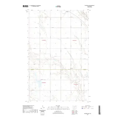
2020 Map of Waterloo Lake
USGS Topo · Published 2020About this map
Milton sits at the northern edge of this North Dakota landscape, where the agricultural grid is deeply etched by the winding branches of the Park River. The terrain is defined by the hydrologic network of the S Br Park River, Middle Br Park River, and the Br Park River, which create a complex drainage pattern across the prairie. This 2020 survey documents the rural character of the borderlands between Cavalier and Walsh counties, preserving the location of local landmarks like the Hitterdal Cem and Saint Stephens Lutheran Cem. The eponymous Waterloo Lake provides a notable focal point in the southwestern section, surrounded by numerous small prairie potholes and wetlands. The map illustrates a highly organized township system, with a network of section-line roads such as 81st St NE and Co Hwy 1 that facilitate movement through this sparsely populated farming region.
Find a feature on this map
25 named features on this map. Tap any name to fly to it.
Don’t see what you’re looking for? This feature index may not catch every label — zoom into the map to look around manually.
Map Details
Editions of this 2020 Waterloo Lake Map
This is the sole edition of this map. No revisions or reprints were ever made.
Other maps of this area

1952 · Thief River Falls
USGS Topo · 1:250,000

1953 · Devils Lake
USGS Topo · 1:250,000

1956 · Thief River Falls
USGS Topo · 1:250,000

1956 · Devils Lake
USGS Topo · 1:250,000

1957 · Thief River Falls
USGS Topo · 1:250,000
1964 · Concrete
USGS Topo · 1:24,000

1967 · Thief River Falls
USGS Topo · 1:250,000

1972 · Osnabrock
USGS Topo · 1:24,000
1972 · Milton
USGS Topo · 1:24,000

1972 · Osnabrock SW
USGS Topo · 1:24,000