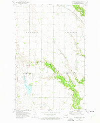
1972 Map of Waterloo Lake
USGS Topo · Published 1975About this map
Waterloo Lake and its surrounding wetlands serve as a central feature of this 1970s landscape on the border of Cavalier and Walsh counties. Much of the western terrain is protected as a National Waterfowl Production Area, reflecting a region dedicated to conservation alongside agriculture. The town of Milton occupies the northern edge, situated along the Burlington Northern railroad corridor.
Find a feature on this map
19 named features on this map. Tap any name to fly to it.
Don’t see what you’re looking for? This feature index may not catch every label — zoom into the map to look around manually.
Map Details
Editions of this 1972 Waterloo Lake Map
This is the sole edition of this map. No revisions or reprints were ever made.
Other maps of this area

1952 · Thief River Falls
USGS Topo · 1:250,000

1953 · Devils Lake
USGS Topo · 1:250,000

1956 · Thief River Falls
USGS Topo · 1:250,000

1956 · Devils Lake
USGS Topo · 1:250,000

1957 · Thief River Falls
USGS Topo · 1:250,000
1964 · Concrete
USGS Topo · 1:24,000

1967 · Thief River Falls
USGS Topo · 1:250,000

1972 · Osnabrock
USGS Topo · 1:24,000
1972 · Milton
USGS Topo · 1:24,000

1972 · Osnabrock SW
USGS Topo · 1:24,000