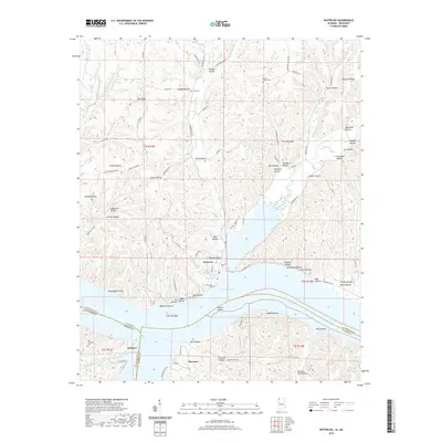
2020 Map of Waterloo
USGS Topo · Published 2020About this map
Waterloo sits at the confluence where Second Creek meets the wide expanse of Pickwick Lake, a landscape defined by the intersection of Lauderdale County, Alabama, and Tishomingo County, Mississippi. This 2020 survey documents a region characterized by complex drainage systems and numerous named hollows, such as Tanyard Hollow and Wolfpen Hollow, which carve through Pea Ridge and Manbone Ridge. The southern portion of the map focuses on the river-border settlements of Eastport and Riverton, positioned near the historic Colbert Shoals. For genealogists, the map identifies several burial sites, including the Old Eastport Cem and Richardson Cem, providing precise locations for ancestral research. The intricate network of county roads, like Lauderdale Co 14 and Till Hollow Rd, reveals the modern connectivity of these historic Tennessee River landings.
Find a feature on this map
96 named features on this map. Tap any name to fly to it.
Don’t see what you’re looking for? This feature index may not catch every label — zoom into the map to look around manually.
Map Details
Editions of this 2020 Waterloo Map
This is the sole edition of this map. No revisions or reprints were ever made.
Other maps of this area

1905 · Waynesboro
USGS Topo · 1:125,000

1911 · Iuka
USGS Topo · 1:48,000

1914 · Iuka
USGS Topo · 1:62,500

1924 · Gravelly Springs
USGS Topo · 1:48,000

1926 · Gravelly Springs
USGS Topo · 1:62,500

1935 · Cherokee
USGS Topo · 1:24,000

1935 · Wright
USGS Topo · 1:24,000

1935 · Iuka
USGS Topo · 1:24,000

1936 · Margerum
USGS Topo · 1:24,000

1936 · Waterloo
USGS Topo · 1:24,000