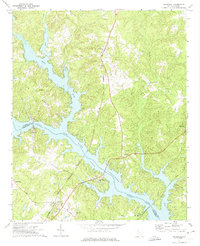
1971 Map of Waterloo
USGS Topo · Published 1975About this map
Lake Greenwood dominates the landscape of this 1970s survey, marking the confluence where the Reedy River and Saluda River meet at a point known as The Forks. The map documents a period of established lakeside development alongside older agrarian and industrial footprints, such as Laurel Mill and the Seaboard Coast Line railroad which cuts through Waterloo. Small rural communities and crossroads like Harris Springs and Coronaca are detailed with their essential local institutions, including Smyrna Ch, Bethlehem Ch, and Good Hope Ch. This record is particularly valuable for genealogists, as it preserves the locations of numerous family-named landmarks and burial grounds like Franklin Cem and Bethlehem Cem before further modern residential expansion along the irregular shoreline.
Find a feature on this map
31 named features on this map. Tap any name to fly to it.
Don’t see what you’re looking for? This feature index may not catch every label — zoom into the map to look around manually.
Map Details
Editions of this 1971 Waterloo Map
This is the sole edition of this map. No revisions or reprints were ever made.
Other maps of this area

1892 · Abbeville
USGS Topo · 1:125,000

1941 · Spartanburg
USGS Topo · 1:250,000

1949 · Ninety-Six
USGS Topo · 1:24,000

1949 · Greenwood
USGS Topo · 1:24,000

1953 · Spartanburg
USGS Topo · 1:250,000

1954 · Greenville
USGS Topo · 1:250,000

1958 · Greenville
USGS Topo · 1:250,000

1960 · Spartanburg
USGS Topo · 1:250,000

1963 · Spartanburg
USGS Topo · 1:250,000

1964 · Spartanburg
USGS Topo · 1:250,000