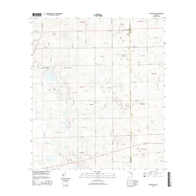
2015 Map of Waters Lake
USGS Topo · Published 2015About this map
The borderlands of Gilchrist and Alachua Counties are defined by a landscape of karst features and scattered small-scale agriculture in this 2015 survey. The topography is marked by numerous isolated depressions and ponds, ranging from the prominent Waters Lake in the northwest to Dinner Pond and Fivemile Pond further south. These water bodies, along with Knighting Lake and Jeb Knight Pond, suggest a subterranean drainage system characteristic of the Florida lime sink region. Settlement patterns remain relatively dispersed, concentrated around the community of Newberry on the eastern edge and the smaller locality of Thames. Aviation is a notable feature of this rural landscape, with the presence of both Rush Airport and the Oak Tree Landing Strip serving the local area. The Dry Prairie Hammock provides a glimpse into the native ecology, situated among a network of county roads and section lines that grid the limestone plains.
Find a feature on this map
141 named features on this map. Tap any name to fly to it.
Don’t see what you’re looking for? This feature index may not catch every label — zoom into the map to look around manually.
Map Details
Editions of this 2015 Waters Lake Map
This is the sole edition of this map. No revisions or reprints were ever made.
Other maps of this area

1954 · Gainesville
USGS Topo · 1:250,000

1958 · Gainesville
USGS Topo · 1:250,000

1959 · Gainesville
USGS Topo · 1:250,000

1962 · High Springs
USGS Topo · 1:24,000

1968 · Newberry SW
USGS Topo · 1:24,000

1968 · Waters Lake
USGS Topo · 1:24,000
1968 · Archer
USGS Topo · 1:24,000

1968 · Newberry
USGS Topo · 1:24,000

1968 · Fourmile Lake
USGS Topo · 1:24,000

1968 · Trenton
USGS Topo · 1:24,000