1985 Map of Watertown
USGS Topo · Published 1991About this map
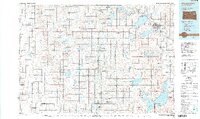
Watertown serves as the regional hub for this prairie landscape, situated near the shores of Lake Kampeska and Pelican Lake. The mid-1980s terrain is defined by a dense network of glacial lakes and waterfowl production areas, such as the Opdahl Slough SGPA and Spirit Lake SGPA, reflecting a conservation-minded land use pattern. Transportation across the plains is facilitated by both the Chicago and North Western and Burlington Northern railroads, which connect smaller agricultural settlements like Castlewood, Hayti, and Arlington.
Find a feature on this map
147 named features on this map. Tap any name to fly to it.
Don’t see what you’re looking for? This feature index may not catch every label — zoom into the map to look around manually.
Map Details
Editions of this 1985 Watertown Map
2 editions found

Other maps of this area

1894 · Conde
USGS Topo · 1:62,500

1895 · Byron
USGS Topo · 1:125,000

1895 · Aberdeen
USGS Topo · 1:125,000

1898 · Huron
USGS Topo · 1:125,000

1899 · De Smet
USGS Topo · 1:125,000

1953 · Milbank
USGS Topo · 1:250,000

1953 · Huron
USGS Topo · 1:250,000

1953 · Watertown
USGS Topo · 1:250,000

1954 · Aberdeen
USGS Topo · 1:250,000

1954 · Huron
USGS Topo · 1:250,000
Featured Places
- Watertown, SD
- Clark, SD
- Castlewood, Castlewood Township
- Lake Norden, Norden Township
- Bryant, Garfield Township