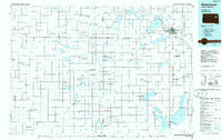
1985 Map of Watertown
USGS Topo · Published 1985About this map
The Big Sioux River and a dense network of glacial lakes define this 1980s landscape across eastern South Dakota. Centered on Watertown, the map reveals a region heavily managed for conservation, dotted with numerous State Game Production Areas such as North Dry Lake and Blythe. Large water bodies like Lake Kampeska, Pelican Lake, and Lake Poinsett serve as focal points for the surrounding rural communities.
Find a feature on this map
84 named features on this map. Tap any name to fly to it.
Don’t see what you’re looking for? This feature index may not catch every label — zoom into the map to look around manually.
Map Details
Editions of this 1985 Watertown Map
2 editions found
Other maps of this area

1894 · Conde
USGS Topo · 1:62,500

1895 · Byron
USGS Topo · 1:125,000

1895 · Aberdeen
USGS Topo · 1:125,000

1898 · Huron
USGS Topo · 1:125,000

1899 · De Smet
USGS Topo · 1:125,000

1953 · Milbank
USGS Topo · 1:250,000

1953 · Huron
USGS Topo · 1:250,000

1953 · Watertown
USGS Topo · 1:250,000

1954 · Aberdeen
USGS Topo · 1:250,000

1954 · Huron
USGS Topo · 1:250,000