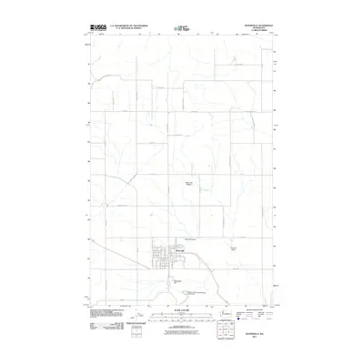
2011 Map of Waterville
USGS Topo · Published 2011About this map
Waterville serves as the primary hub of activity in this high desert region, sitting at the intersection of a grid-iron street plan and the vast expanse of the Waterville Plateau. The town’s residential and commercial core is clearly defined by landmarks such as the Waterville Airport to the north and Standpipe Hill to the south. The landscape is marked by a network of rural roads, including Hardin Rd NW and Browns Canyon Rd NW, which provide access to the surrounding agricultural and open lands. Local geography is shaped by drainages like Kummer Draw, while modern infrastructure is represented by the Waterville Sewage Disposal Pond Dam. This 2011 survey illustrates the continued importance of this settlement as a pocket of development amidst the sweeping terrain of Douglas County.
Find a feature on this map
59 named features on this map. Tap any name to fly to it.
Don’t see what you’re looking for? This feature index may not catch every label — zoom into the map to look around manually.
Map Details
Editions of this 2011 Waterville Map
This is the sole edition of this map. No revisions or reprints were ever made.
Other maps of this area

1901 · Chelan
USGS Topo · 1:125,000

1953 · Ritzville
USGS Topo · 1:250,000

1957 · Wenatchee
USGS Topo · 1:250,000

1959 · Ritzville
USGS Topo · 1:250,000

1965 · Ritzville
USGS Topo · 1:250,000

1968 · Chelan
USGS Topo · 1:24,000

1968 · Lamoine
USGS Topo · 1:24,000

1968 · Chelan Falls
USGS Topo · 1:24,000
1968 · Alstown
USGS Topo · 1:24,000

1968 · Orondo
USGS Topo · 1:24,000