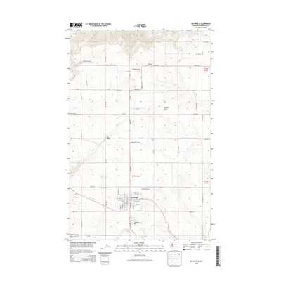
2014 Map of Waterville
USGS Topo · Published 2014About this map
Waterville serves as the central hub of this agricultural landscape in central Washington, positioned where the high plains of the Waterville Plateau meet the carved drainages of the Columbia River basin. The town layout is defined by a grid of streets including W Ash St, W Walnut St, and E Birch St, with the Waterville Airport situated just to the east. The surrounding terrain is marked by significant topographical shifts, from the heights of Standpipe Hill to the deep recesses of Pine Canyon and Greens Canyon.
Find a feature on this map
42 named features on this map. Tap any name to fly to it.
Don’t see what you’re looking for? This feature index may not catch every label — zoom into the map to look around manually.
Map Details
Editions of this 2014 Waterville Map
This is the sole edition of this map. No revisions or reprints were ever made.
Other maps of this area

1901 · Chelan
USGS Topo · 1:125,000

1953 · Ritzville
USGS Topo · 1:250,000

1957 · Wenatchee
USGS Topo · 1:250,000

1959 · Ritzville
USGS Topo · 1:250,000

1965 · Ritzville
USGS Topo · 1:250,000

1968 · Chelan
USGS Topo · 1:24,000

1968 · Lamoine
USGS Topo · 1:24,000

1968 · Chelan Falls
USGS Topo · 1:24,000
1968 · Alstown
USGS Topo · 1:24,000

1968 · Orondo
USGS Topo · 1:24,000