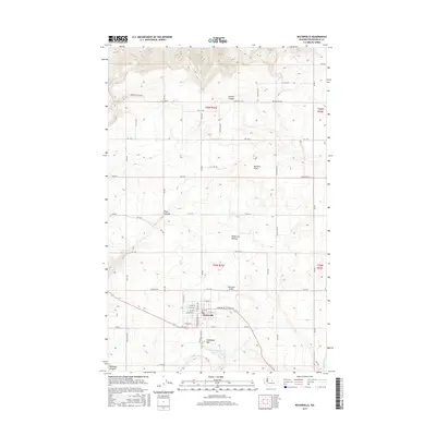
2017 Map of Waterville
USGS Topo · Published 2017About this map
Waterville sits at the heart of this high-desert landscape in Douglas County, serving as a primary hub for the surrounding agricultural community. The town's grid is clearly defined by landmarks such as Standpipe Hill to the south and the Waterville Airport just to the north. This 2017 survey illustrates a plateau environment deeply incised by natural drainage features, including the dramatic Brown's Canyon and Pine Canyon to the west. The transition from the flat Waterville Plateau to the complex relief of Greens Canyon and Kummer Draw reveals the rugged geological character of the region. Local infrastructure is represented by a precise network of rural roads and the Waterville Sewage Disposal Pond, while the southern edge of the sheet traces the path of Douglas Cr.
Find a feature on this map
60 named features on this map. Tap any name to fly to it.
Don’t see what you’re looking for? This feature index may not catch every label — zoom into the map to look around manually.
Map Details
Editions of this 2017 Waterville Map
This is the sole edition of this map. No revisions or reprints were ever made.
Other maps of this area

1901 · Chelan
USGS Topo · 1:125,000

1953 · Ritzville
USGS Topo · 1:250,000

1957 · Wenatchee
USGS Topo · 1:250,000

1959 · Ritzville
USGS Topo · 1:250,000

1965 · Ritzville
USGS Topo · 1:250,000

1968 · Chelan
USGS Topo · 1:24,000

1968 · Lamoine
USGS Topo · 1:24,000

1968 · Chelan Falls
USGS Topo · 1:24,000
1968 · Alstown
USGS Topo · 1:24,000

1968 · Orondo
USGS Topo · 1:24,000