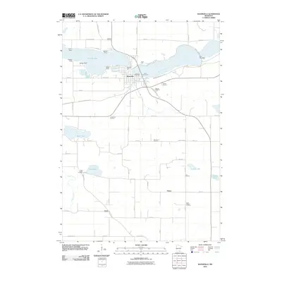
2010 Map of Waterville
USGS Topo · Published 2010About this map
Waterville sits at the focal point of this regional study, established between the waters of Tetonka Lake and the Cannon River. The town's layout is closely tied to the water, featuring the Waterville Post Office and the Tetonka Dam where White Water Creek exits the lake. This landscape is defined by its numerous family and community burial grounds, providing a dense record for genealogical research through sites like Gishville Cemetery, Sakatah Cemetery, and Calvary Cemetery. To the south, the terrain transitions into a grid of rural roads and scattered settlements like Palmer. The map tracks the winding path of the Sakatah Singing Hills Trl, following the corridor of an old rail line. Along the lakeshore, distinctive points such as Crams Point and McPete Point mark the irregular northern coast, while southern waters like Reeds Lake and Toners Lake dot the agricultural landscape.
Find a feature on this map
63 named features on this map. Tap any name to fly to it.
Don’t see what you’re looking for? This feature index may not catch every label — zoom into the map to look around manually.
Map Details
Editions of this 2010 Waterville Map
This is the sole edition of this map. No revisions or reprints were ever made.
Other maps of this area

1953 · Saint Paul
USGS Topo · 1:250,000

1959 · Saint Paul
USGS Topo · 1:250,000

1960 · Shieldsville
USGS Topo · 1:24,000

1962 · Morristown
USGS Topo · 1:24,000

1962 · Meriden
USGS Topo · 1:24,000

1966 · Waseca
USGS Topo · 1:24,000

1966 · Janesville
USGS Topo · 1:24,000

1966 · Waterville
USGS Topo · 1:24,000

1966 · Cordova
USGS Topo · 1:24,000

1966 · Elysian
USGS Topo · 1:24,000