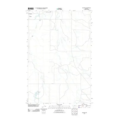
2011 Map of Watkins
USGS Topo · Published 2011About this map
Watkins and the surrounding rangeland of eastern Montana define this landscape, where water management is central to the local economy. The map reveals a network of small dams and reservoirs, including Jordan Reservoir Number 1 Dam and Jordan Reservoir Number 2 Dam, which harness the intermittent flow of the Redwater River and Trail Creek. This pattern of water capture is visible throughout the area, with several other structures such as Hughes Dam and Thorn Dam situated along the drainage of Duck Creek.
Find a feature on this map
18 named features on this map. Tap any name to fly to it.
Don’t see what you’re looking for? This feature index may not catch every label — zoom into the map to look around manually.
Map Details
Editions of this 2011 Watkins Map
This is the sole edition of this map. No revisions or reprints were ever made.
Other maps of this area

1954 · Glendive
USGS Topo · 1:250,000

1957 · Glendive
USGS Topo · 1:250,000

1958 · Glendive
USGS Topo · 1:250,000

1965 · Heitz School
USGS Topo · 1:24,000

1965 · Watkins SE
USGS Topo · 1:24,000

1965 · Watkins
USGS Topo · 1:24,000
1965 · Berry School
USGS Topo · 1:24,000

1982 · Circle
USGS Topo · 1:100,000
1983 · Big Sheep Mountain
USGS Topo · 1:24,000
1983 · Brockway
USGS Topo · 1:24,000