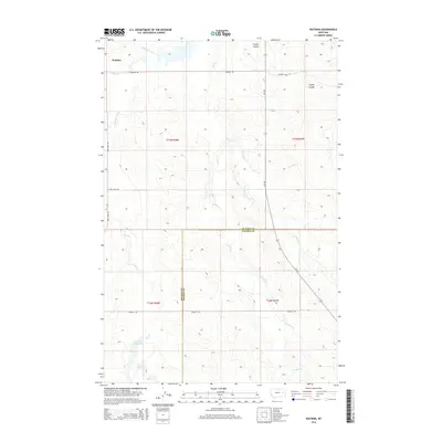
2014 Map of Watkins
USGS Topo · Published 2014About this map
Watkins sits at the northern edge of this high plains landscape, situated near the confluence of Redwater River and Trail Cr. The terrain is defined by a complex network of drainage systems, including the branching paths of W Duck Cr, E Duck Cr, and Dunlap Cr. The southern portion of the map is marked by the Lisk Cr Reservoir, a significant water feature fed by Lisk Cr that highlights the importance of water management in this cattle-ranching region. This 2014 survey captures the boundary between McCone and Prairie Counties, a line crossed by several rural arteries like MT-253 and Bob Fudge Rd. The presence of named geographic features like Fryxell Coulee alongside modern road networks like Watkins Rd provides a clear view of the ranching infrastructure and hydrological patterns that sustain life in this part of Montana.
Find a feature on this map
22 named features on this map. Tap any name to fly to it.
Don’t see what you’re looking for? This feature index may not catch every label — zoom into the map to look around manually.
Map Details
Editions of this 2014 Watkins Map
This is the sole edition of this map. No revisions or reprints were ever made.
Other maps of this area

1954 · Glendive
USGS Topo · 1:250,000

1957 · Glendive
USGS Topo · 1:250,000

1958 · Glendive
USGS Topo · 1:250,000

1965 · Heitz School
USGS Topo · 1:24,000

1965 · Watkins SE
USGS Topo · 1:24,000

1965 · Watkins
USGS Topo · 1:24,000
1965 · Berry School
USGS Topo · 1:24,000

1982 · Circle
USGS Topo · 1:100,000
1983 · Big Sheep Mountain
USGS Topo · 1:24,000
1983 · Brockway
USGS Topo · 1:24,000