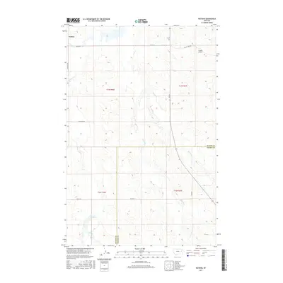
2017 Map of Watkins
USGS Topo · Published 2017About this map
Watkins serves as the focal point for this corner of eastern Montana, where the terrain is defined by the drainage networks of the Redwater River and its numerous tributaries. The landscape is marked by the distinct dividing line between McCone Co and Prairie Co, crossing through an area characterized by coulees and creek beds. Water management in this semi-arid region is anchored by the Lisk Cr Reservoir, which captures runoff from Lisk Cr. The naming of local infrastructure, such as Bob Fudge Rd and Pasture Creek Rd, reflects the ranching heritage of the territory. The map illustrates a high degree of hydrographic detail, tracing the courses of Duck Cr, W Duck Cr, and E Duck Cr as they navigate the breaks, including the sharp contours of Fryxell Coulee.
Find a feature on this map
21 named features on this map. Tap any name to fly to it.
Don’t see what you’re looking for? This feature index may not catch every label — zoom into the map to look around manually.
Map Details
Editions of this 2017 Watkins Map
This is the sole edition of this map. No revisions or reprints were ever made.
Other maps of this area

1954 · Glendive
USGS Topo · 1:250,000

1957 · Glendive
USGS Topo · 1:250,000

1958 · Glendive
USGS Topo · 1:250,000

1965 · Heitz School
USGS Topo · 1:24,000

1965 · Watkins SE
USGS Topo · 1:24,000

1965 · Watkins
USGS Topo · 1:24,000
1965 · Berry School
USGS Topo · 1:24,000

1982 · Circle
USGS Topo · 1:100,000
1983 · Big Sheep Mountain
USGS Topo · 1:24,000
1983 · Brockway
USGS Topo · 1:24,000