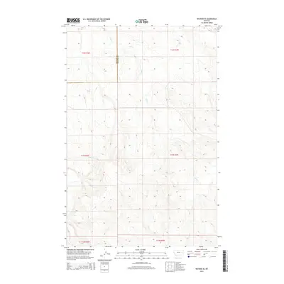
2014 Map of Watkins SE
USGS Topo · Published 2014About this map
Redwater River flows across this high plains landscape on the border of McCone and Prairie Counties, where the drainage patterns of the Missouri River basin are clearly defined. The terrain is marked by seasonal watercourses and localized water sources such as Morton Spring, which would have been critical landmarks in this semi-arid region. Tributaries including Lisk Cr, Timber Cr, and the E Fk Timber Cr create a complex network of draws and ridges. The map illustrates the meticulous Public Land Survey System divisions of Townships 14, 15, and 16 North across Ranges 46 and 47 East, reflecting the systematic settlement and ranching history of eastern Montana. Far to the northeast, the headwaters of W Duck Cr emerge, showing the subtle topographic shifts that direct water across these expansive cattle-country highlands.
Find a feature on this map
13 named features on this map. Tap any name to fly to it.
Don’t see what you’re looking for? This feature index may not catch every label — zoom into the map to look around manually.
Map Details
Editions of this 2014 Watkins SE Map
This is the sole edition of this map. No revisions or reprints were ever made.
Other maps of this area

1953 · Miles City
USGS Topo · 1:250,000

1954 · Glendive
USGS Topo · 1:250,000

1957 · Miles City
USGS Topo · 1:250,000

1957 · Glendive
USGS Topo · 1:250,000

1958 · Miles City
USGS Topo · 1:250,000

1958 · Glendive
USGS Topo · 1:250,000

1965 · Little Sheep Mountain
USGS Topo · 1:24,000

1965 · Heitz School
USGS Topo · 1:24,000
1965 · Combs Ranch
USGS Topo · 1:24,000

1965 · Watkins SE
USGS Topo · 1:24,000