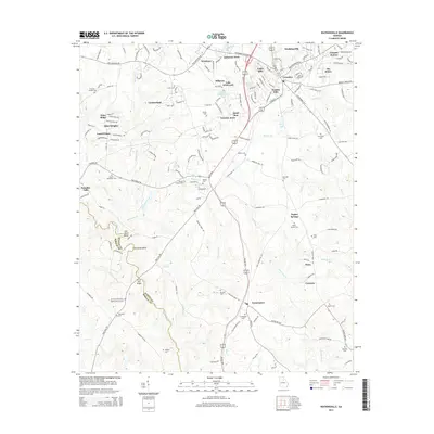
2014 Map of Watkinsville
USGS Topo · Published 2014About this map
Watkinsville serves as the focal point for this 2014 survey, illustrating the suburban and residential growth of Oconee County as it developed north of the Apalachee River. The landscape is a transition from established residential developments like Victoria Station, Crossties, and Harden Hills to more rural stretches south toward Farmington. For genealogists and local historians, the sheet is exceptionally detailed with family-named burial grounds and historic church sites, including Mt Perry Missionary Baptist Church Cem and Brown Chapel Cem. The river's winding path creates distinctive terrain features such as Gun Point Bend and Horseshoe Bend, while industrial history is represented by the Price Mill Bridge. The network of small waterways, such as Greenbrier Cr and Robinson Creek, defines the drainage patterns of this Piedmont region.
Find a feature on this map
156 named features on this map. Tap any name to fly to it.
Don’t see what you’re looking for? This feature index may not catch every label — zoom into the map to look around manually.
Map Details
Editions of this 2014 Watkinsville Map
This is the sole edition of this map. No revisions or reprints were ever made.
Other maps of this area

1896 · Monroe
USGS Topo · 1:125,000

1953 · Athens
USGS Topo · 1:250,000

1958 · Athens
USGS Topo · 1:250,000

1959 · Athens
USGS Topo · 1:250,000

1963 · Athens
USGS Topo · 1:250,000

1964 · Athens West
USGS Topo · 1:24,000

1964 · Barnett Shoals
USGS Topo · 1:24,000

1964 · High Shoals
USGS Topo · 1:24,000

1964 · Watkinsville
USGS Topo · 1:24,000
1964 · Statham
USGS Topo · 1:24,000