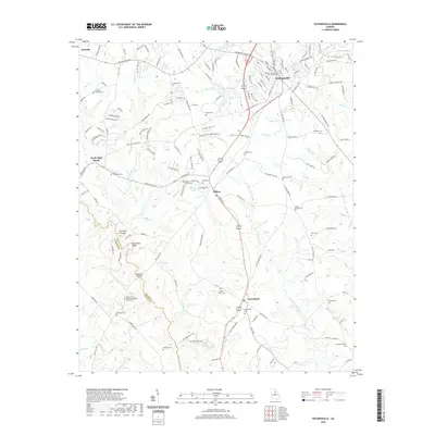
2020 Map of Watkinsville
USGS Topo · Published 2020About this map
Watkinsville serves as the focal point for this Oconee County landscape, anchored by the Oconee County Courthouse and a network of residential roads like Southland Dr and Limerick Dr. The topography follows a series of waterways, including Porters Creek and Greenbrier Creek, which feed into the Apalachee River at the western boundary. This survey documents the rural character of the area through its numerous family and community burial grounds, such as Klutts Cem and Hardigree Cem, which are scattered between the small settlements of Bishop, Farmington, and North High Shoals.
Find a feature on this map
155 named features on this map. Tap any name to fly to it.
Don’t see what you’re looking for? This feature index may not catch every label — zoom into the map to look around manually.
Map Details
Editions of this 2020 Watkinsville Map
This is the sole edition of this map. No revisions or reprints were ever made.
Other maps of this area

1896 · Monroe
USGS Topo · 1:125,000

1953 · Athens
USGS Topo · 1:250,000

1958 · Athens
USGS Topo · 1:250,000

1959 · Athens
USGS Topo · 1:250,000

1963 · Athens
USGS Topo · 1:250,000

1964 · Athens West
USGS Topo · 1:24,000

1964 · Barnett Shoals
USGS Topo · 1:24,000

1964 · High Shoals
USGS Topo · 1:24,000

1964 · Watkinsville
USGS Topo · 1:24,000
1964 · Statham
USGS Topo · 1:24,000