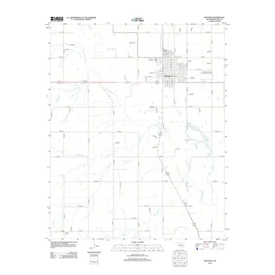
2012 Map of Watonga
USGS Topo · Published 2012About this map
The town of Watonga serves as the central hub of this Blaine County landscape, where the street grid transitions into a vast network of section roads. The map illustrates a community deeply connected to its history through several burial sites, including the Watonga Independent Order of Odd Fellows Cem and the Watonga Indian Cem on the town's northern edge. To the southwest, near the confluence of local tributaries, the Worrells Cem and Pinkerton Cem mark early family or settlement sites. The North Canadian River meanders across the territory, joined by local waterways such as Weavers Cr, Chicken Cr, and Relay Cr. Modern infrastructure is represented by the Watonga Regional Airport and Club Lake, showing how the rural landscape has adapted for aviation and recreation while maintaining its foundational agricultural layout.
Find a feature on this map
68 named features on this map. Tap any name to fly to it.
Don’t see what you’re looking for? This feature index may not catch every label — zoom into the map to look around manually.
Map Details
Editions of this 2012 Watonga Map
This is the sole edition of this map. No revisions or reprints were ever made.
Other maps of this area

1942 · Geary
USGS Topo · 1:62,500

1955 · Clinton
USGS Topo · 1:250,000

1957 · Clinton
USGS Topo · 1:250,000

1964 · Oakwood
USGS Topo · 1:62,500

1964 · Weatherford
USGS Topo · 1:62,500

1972 · Watonga
USGS Topo · 1:24,000

1972 · Watonga SE
USGS Topo · 1:24,000
1972 · Watonga Lake
USGS Topo · 1:24,000
1972 · Hitchcock
USGS Topo · 1:24,000
1979 · Geary North
USGS Topo · 1:24,000