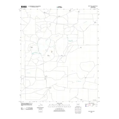
2010 Map of Watts Hill
USGS Topo · Published 2010About this map
Cibolo Creek meanders through this De Baca County landscape, defining the hydrology of a region where water sources are vital for livestock and settlement. The map documents a classic New Mexico ranching environment, anchored by sites like Jones Camp and Colter Ranch. The terrain is marked by prominent elevations such as Table Mountain, Dipping Vat Hill, and the namesake Watts Hill, which rise above the surrounding plains. The extensive network of named windmills, including Soda Windmill, Shoemake Windmill, and Wharton Windmill, underscores the importance of groundwater management in this arid territory. Near the center of the sheet, Alkali Lake serves as a notable landmark alongside several named tanks and springs, such as Boven Spring Chimney Tank and Watts Spring, reflecting the essential infrastructure of the local high plains economy.
Find a feature on this map
35 named features on this map. Tap any name to fly to it.
Don’t see what you’re looking for? This feature index may not catch every label — zoom into the map to look around manually.
Map Details
Editions of this 2010 Watts Hill Map
This is the sole edition of this map. No revisions or reprints were ever made.
Other maps of this area

1954 · Fort Sumner
USGS Topo · 1:250,000

1954 · Clovis
USGS Topo · 1:250,000

1958 · Fort Sumner
USGS Topo · 1:250,000

1958 · Clovis
USGS Topo · 1:250,000

1967 · Eighteenmile Hill
USGS Topo · 1:24,000
1967 · Howell Ranch
USGS Topo · 1:24,000
1967 · Watts Hill
USGS Topo · 1:24,000
1967 · Cooley Lake
USGS Topo · 1:24,000

1968 · Lomas Gatos
USGS Topo · 1:24,000

1968 · Bonner Lake
USGS Topo · 1:24,000