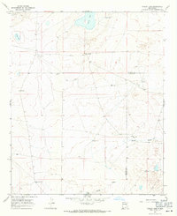
1967 Map of Cooley Lake
USGS Topo · Published 1971About this map
McDowell Ranch and Good Ranch anchor this landscape in the late 1960s, a period defined by large-scale livestock operations on the high plains of East Central New Mexico. The geography is dominated by ephemeral water sources and critical ranching infrastructure, including several named windmills like North Spy Windmill and Heifer Windmill that provided the lifeblood for cattle in this arid environment. The map records a series of distinct basins such as Urton Lake, Cooley Lake, and Salt Lake, which alongside the path of White Draw, illustrate the natural drainage patterns that dictated settlement locations. The boundary between De Baca and Chaves Counties is clearly delineated, crossing a terrain where fence lines, recorded here by the U.S. Geological Survey, served as the primary markers of human presence across the open range.
Find a feature on this map
17 named features on this map. Tap any name to fly to it.
Don’t see what you’re looking for? This feature index may not catch every label — zoom into the map to look around manually.
Map Details
Editions of this 1967 Cooley Lake Map
2 editions found
Other maps of this area

1954 · Fort Sumner
USGS Topo · 1:250,000

1955 · Roswell
USGS Topo · 1:250,000

1958 · Fort Sumner
USGS Topo · 1:250,000

1958 · Roswell
USGS Topo · 1:250,000

1962 · Roswell
USGS Topo · 1:250,000

1967 · Deering Place
USGS Topo · 1:24,000

1967 · Eighteenmile Hill
USGS Topo · 1:24,000

1967 · Hernandez Lake
USGS Topo · 1:24,000
1967 · La Espia Peak
USGS Topo · 1:24,000
1967 · Conejo Creek East
USGS Topo · 1:24,000