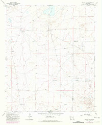
1967 Map of Cooley Lake
USGS Topo · Published 1982About this map
McDowell Ranch and Good Ranch anchor this landscape along the boundary of De Baca and Chaves Counties, representing the mid-century ranching heritage of east-central New Mexico. The terrain is defined by low-lying basins and ephemeral water sources, most notably the wide corridor of White Draw which traverses the lower half of the quadrangle. Surface water is scarce and localized, found at Urton Lake, Cooley Lake, and Salt Lake.
Find a feature on this map
17 named features on this map. Tap any name to fly to it.
Don’t see what you’re looking for? This feature index may not catch every label — zoom into the map to look around manually.
Map Details
Editions of this 1967 Cooley Lake Map
2 editions found
Other maps of this area

1954 · Fort Sumner
USGS Topo · 1:250,000

1955 · Roswell
USGS Topo · 1:250,000

1958 · Fort Sumner
USGS Topo · 1:250,000

1958 · Roswell
USGS Topo · 1:250,000

1962 · Roswell
USGS Topo · 1:250,000

1967 · Deering Place
USGS Topo · 1:24,000

1967 · Eighteenmile Hill
USGS Topo · 1:24,000

1967 · Hernandez Lake
USGS Topo · 1:24,000
1967 · La Espia Peak
USGS Topo · 1:24,000
1967 · Conejo Creek East
USGS Topo · 1:24,000