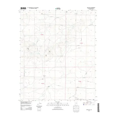
2013 Map of Watts Hill
USGS Topo · Published 2013About this map
Colter Ranch and Jones Camp anchor this landscape in eastern New Mexico, where water management defines the pattern of human presence. The map reveals an intricate network of livestock-oriented infrastructure, including numerous named windmills such as Shoemake Windmill, Payne Windmill, and Carroll Windmill. These water sources are vital across the drainage of Cibolo Cr and surrounding springs like Watts Spring and Black Spring.
Find a feature on this map
45 named features on this map. Tap any name to fly to it.
Don’t see what you’re looking for? This feature index may not catch every label — zoom into the map to look around manually.
Map Details
Editions of this 2013 Watts Hill Map
This is the sole edition of this map. No revisions or reprints were ever made.
Other maps of this area

1954 · Fort Sumner
USGS Topo · 1:250,000

1954 · Clovis
USGS Topo · 1:250,000

1958 · Fort Sumner
USGS Topo · 1:250,000

1958 · Clovis
USGS Topo · 1:250,000

1967 · Eighteenmile Hill
USGS Topo · 1:24,000
1967 · Howell Ranch
USGS Topo · 1:24,000
1967 · Watts Hill
USGS Topo · 1:24,000
1967 · Cooley Lake
USGS Topo · 1:24,000

1968 · Lomas Gatos
USGS Topo · 1:24,000

1968 · Bonner Lake
USGS Topo · 1:24,000