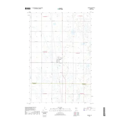
2019 Map of Waubun
USGS Topo · Published 2019About this map
Waubun serves as the primary hub of this northern Minnesota landscape, situated at the intersection of a grid-iron road network and several significant wetlands. The town's layout is centered along Main St and Waller Ave, with community history anchored at Saint Anns Cem and the larger Waubun Cem to the south. The surrounding terrain is characterized by numerous glacial depressions, forming a dense pattern of lakes and watercourses including Santwire Lake, Waubun Lake, and Moore Lake. In the northeast, the White Earth River meanders through the township of T144N R41W, while the southern reaches cross into the border of Mahnomen Co Becker Co. The distribution of section lines and township roads like Co St Aid Hwy 10 illustrates the late-period rural development in this part of the White Earth Reservation area.
Find a feature on this map
44 named features on this map. Tap any name to fly to it.
Don’t see what you’re looking for? This feature index may not catch every label — zoom into the map to look around manually.
Map Details
Editions of this 2019 Waubun Map
This is the sole edition of this map. No revisions or reprints were ever made.
Other maps of this area

1918 · Flom
USGS Topo · 1:62,500

1952 · Grand Forks
USGS Topo · 1:250,000

1954 · Bemidji
USGS Topo · 1:250,000

1956 · Grand Forks
USGS Topo · 1:250,000

1957 · Bemidji
USGS Topo · 1:250,000

1958 · Bemidji
USGS Topo · 1:250,000

1966 · Grand Forks
USGS Topo · 1:250,000
1966 · Flom SE
USGS Topo · 1:24,000
1966 · Flom NE
USGS Topo · 1:24,000
1966 · Faith
USGS Topo · 1:24,000