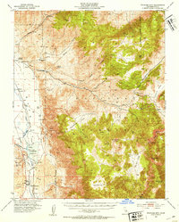
1951 Map of Waucoba Mtn
USGS Topo · Published 1953About this map
The high-altitude terrain of the Inyo Mountains dominates this mid-century survey, revealing a landscape defined by mining operations and water management for the Owens Valley. Surveyed just after the war, the map documents a transition in infrastructure, most notably along the western edge where the Southern Pacific Railroad (Dismantled) follows the path of the Owens River near the Tinemaha Reservoir. While small settlements like Monola and the Poverty Hills are visible, much of the human activity is recorded through isolated sites such as Graham Ranch (Site) and the historic Toll House guarding the mountain passage.
Find a feature on this map
54 named features on this map. Tap any name to fly to it.
Don’t see what you’re looking for? This feature index may not catch every label — zoom into the map to look around manually.
Map Details
Editions of this 1951 Waucoba Mtn Map
3 editions found

Other maps of this area

1907 · Mt. Whitney
USGS Topo · 1:125,000

1908 · Lida
USGS Topo · 1:250,000

1908 · Ballarat
USGS Topo · 1:250,000

1913 · Bishop
USGS Topo · 1:125,000

1913 · Lida
USGS Topo · 1:250,000

1913 · Ballarat
USGS Topo · 1:250,000

1919 · Mt. Whitney
USGS Topo · 1:125,000

1937 · Mt. Whitney
USGS Topo · 1:125,000

1947 · Mariposa
USGS Topo · 1:250,000

1948 · Death Valley
USGS Topo · 1:250,000