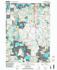
1998 Map of Wauconda
USGS Topo · Published 2003About this map
Glacial topography and waterfront development define this region at the edge of Mc Henry Co Lake Co during the late 1990s. The landscape is characterized by a dense concentration of kettle lakes and wetlands, anchored by the Staten Lake Bog Nature Preserve and Moraine Hills State Park. Residential expansion is evident in the cluster of lakefront communities like Lakemoor, Island Lake, and Holiday Hills, while the larger town of Wauconda sits at the edge of Bangs Lake. The map reveals a mix of recreational and utilitarian land use, including several golf courses and a Drive-in Theater along Lincoln Road. Local history is preserved at the Fisher Family Cem and Grant Cem, while institutions like St Marys Chapel and Crown Sch serve as community landmarks amidst the shifting balance of natural preserves and suburban growth.
Find a feature on this map
70 named features on this map. Tap any name to fly to it.
Don’t see what you’re looking for? This feature index may not catch every label — zoom into the map to look around manually.
Map Details
Editions of this 1998 Wauconda Map
This is the sole edition of this map. No revisions or reprints were ever made.
Other maps of this area

1920 · Grays Lake
USGS Topo · 1:62,500

1923 · Grays Lake
USGS Topo · 1:62,500

1923 · Barrington
USGS Topo · 1:62,500

1925 · Elgin
USGS Topo · 1:62,500

1926 · Mc Henry
USGS Topo · 1:62,500

1935 · Barrington
USGS Topo · 1:62,500

1940 · Elgin
USGS Topo · 1:62,500

1944 · McHenry
USGS Topo · 1:62,500

1954 · Rockford
USGS Topo · 1:250,000

1955 · Rockford
USGS Topo · 1:250,000