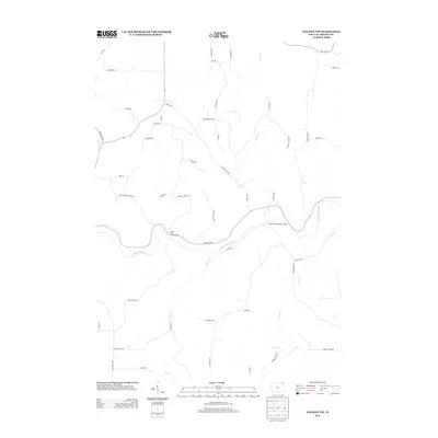
2013 Map of Waukon NW
USGS Topo · Published 2013About this map
The rolling agricultural landscape of northern Allamakee County is defined by the winding course of Waterloo Cr, which cuts through the driftless region's characteristic terrain. This 2013 survey illustrates the modern rural infrastructure of the Waukon Northwest area, where a network of local roads provides access to isolated farmsteads and managed lands. The mapping emphasizes the region's hydrography, showing how minor drainages feed into the larger creek system, which remains a central geographic feature for local land management and environmental study. The layout of these transportation corridors reflects decades of land use patterns, following the natural contours of the Iowa topography to connect the agricultural heartland.
Find a feature on this map
1 named feature on this map. Tap any name to fly to it.
Don’t see what you’re looking for? This feature index may not catch every label — zoom into the map to look around manually.
Map Details
Editions of this 2013 Waukon NW Map
This is the sole edition of this map. No revisions or reprints were ever made.
Other maps of this area

1903 · Waukon
USGS Topo · 1:125,000

1906 · Decorah
USGS Topo · 1:125,000

1956 · Brownsville
USGS Topo · 1:62,500

1958 · La Crosse
USGS Topo · 1:250,000

1961 · La Crosse
USGS Topo · 1:250,000

1965 · La Crosse
USGS Topo · 1:250,000

1965 · Wilmington
USGS Topo · 1:24,000
1968 · Church
USGS Topo · 1:24,000

1968 · Waukon
USGS Topo · 1:24,000
1968 · New Albin
USGS Topo · 1:24,000