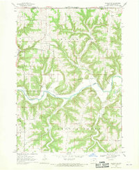
1968 Map of Waukon NW
USGS Topo · Published 1970About this map
The Upper Iowa River cuts a deep, winding path through the dissected plateau of Allamakee County, defining the rural character of this borderland area just south of the Minnesota-Iowa state line. In the late 1960s, the landscape was primarily defined by its drainage systems, including the steep-sided valleys of Waterloo Creek, Clear Creek, and French Creek. This survey captures the sparse but established social infrastructure of the time, centered around community landmarks like the Townhall and local religious sites. Genealogists can identify significant burial grounds such as St Johns Ch Cem in the northeast and Mt Hope Ch Cem near the river, while a local Quarry indicates the small-scale extractive activity characteristic of the region's geology. The map also delineates the civil boundaries of Union City and Hanover townships, providing a clear view of the area's jurisdictional layout before modern developments.
Find a feature on this map
16 named features on this map. Tap any name to fly to it.
Don’t see what you’re looking for? This feature index may not catch every label — zoom into the map to look around manually.
Map Details
Editions of this 1968 Waukon NW Map
This is the sole edition of this map. No revisions or reprints were ever made.
Other maps of this area

1903 · Waukon
USGS Topo · 1:125,000

1906 · Decorah
USGS Topo · 1:125,000

1956 · Brownsville
USGS Topo · 1:62,500

1958 · La Crosse
USGS Topo · 1:250,000

1961 · La Crosse
USGS Topo · 1:250,000

1965 · La Crosse
USGS Topo · 1:250,000

1965 · Wilmington
USGS Topo · 1:24,000
1968 · Church
USGS Topo · 1:24,000

1968 · Waukon
USGS Topo · 1:24,000
1968 · New Albin
USGS Topo · 1:24,000