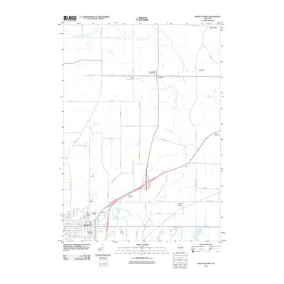
2010 Map of Waupun North
USGS Topo · Published 2010About this map
Waupun occupies the southwestern corner of this survey, anchored by the sprawling grounds of the Waupun Correctional Institution. This institutional presence is further documented by the nearby State Prison Cemetery, one of several burial grounds that dot the agricultural landscape. The township structure is defined by a rigorous grid of rural roads like Church Rd and County Hwy-M, which connect small outlying settlements such as Ladoga and Rogersville. The drainage pattern is dictated by the multiple branches of the Rock River, including the West Branch Rock River and South Branch Rock River, which wind through the glacial terrain alongside Lodoga Creek and Willow Creek. Numerous family and community landmarks, such as Cattaraugus Cemetery and the Spring Brook Landing Strip, provide specific points of interest for local historians and genealogists tracing the development of this Fond du Lac County region.
Find a feature on this map
49 named features on this map. Tap any name to fly to it.
Don’t see what you’re looking for? This feature index may not catch every label — zoom into the map to look around manually.
Map Details
Editions of this 2010 Waupun North Map
This is the sole edition of this map. No revisions or reprints were ever made.
Other maps of this area

1916 · Ripon
USGS Topo · 1:48,000

1918 · Ripon
USGS Topo · 1:62,500

1955 · Waupun
USGS Topo · 1:62,500

1955 · Fox Lake
USGS Topo · 1:62,500

1956 · Ripon
USGS Topo · 1:62,500

1956 · Rosendale
USGS Topo · 1:62,500

1957 · Madison
USGS Topo · 1:250,000

1960 · Madison
USGS Topo · 1:250,000

1975 · Waupun NW
USGS Topo · 1:24,000
1975 · Waupun NE
USGS Topo · 1:24,000