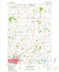
1980 Map of Waupun North
USGS Topo · Published 1981About this map
Waupun serves as the focal point of this 1980 survey, anchored by the significant presence of the State Prison and the adjacent State Prison Farm. The city's grid is meticulously detailed, showing local landmarks like City Hall, the Library, and several educational institutions including Lincoln Sch and Washington Sch. The landscape is a mix of agricultural utility and natural conservation, dominated in the southeast by the expansive Horicon National Wildlife Refuge and the winding course of the West Branch Rock River.
Find a feature on this map
62 named features on this map. Tap any name to fly to it.
Don’t see what you’re looking for? This feature index may not catch every label — zoom into the map to look around manually.
Map Details
Editions of this 1980 Waupun North Map
This is the sole edition of this map. No revisions or reprints were ever made.
Other maps of this area

1916 · Ripon
USGS Topo · 1:48,000

1918 · Ripon
USGS Topo · 1:62,500

1955 · Waupun
USGS Topo · 1:62,500

1955 · Fox Lake
USGS Topo · 1:62,500

1956 · Ripon
USGS Topo · 1:62,500

1956 · Rosendale
USGS Topo · 1:62,500

1957 · Madison
USGS Topo · 1:250,000

1960 · Madison
USGS Topo · 1:250,000

1975 · Waupun NW
USGS Topo · 1:24,000
1975 · Waupun NE
USGS Topo · 1:24,000