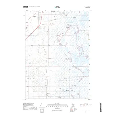
2018 Map of Waupun South
USGS Topo · Published 2018About this map
Waupun and East Waupun sit at the northwestern edge of a vast wetland landscape defined by the upper reaches of the Horicon Marsh. This 2018 survey detail shows a region where the agricultural grid of Dodge County meets the intricate water systems of the West Branch Rock River and the Burnett Flowage. The eastern half of the map is dominated by named islands such as Stony Island, Gardner Island, and Apple Island, which rise out of the marshy terrain. Local history is anchored by the settlement of Burnett in the south, while the Atwater Community Cem and Burnett Union Cem provide specific points of interest for genealogical research. The landscape is heavily modified by drainage infrastructure, visible through features like Sommers Ditch, Luepke Ditch, and Schattunbergs Ditch, illustrating how the land has been managed for both conservation and farming. Nature trails, including the Red Fox Nature Trail and Egret Trail, skirt the marsh edges, highlighting the area's role as a wildlife refuge.
Find a feature on this map
72 named features on this map. Tap any name to fly to it.
Don’t see what you’re looking for? This feature index may not catch every label — zoom into the map to look around manually.
Map Details
Editions of this 2018 Waupun South Map
This is the sole edition of this map. No revisions or reprints were ever made.
Other maps of this area

1955 · Beaver Dam
USGS Topo · 1:62,500

1955 · Waupun
USGS Topo · 1:62,500

1955 · Fox Lake
USGS Topo · 1:62,500

1955 · Horicon
USGS Topo · 1:62,500

1957 · Madison
USGS Topo · 1:250,000

1960 · Madison
USGS Topo · 1:250,000

1975 · Horicon NW
USGS Topo · 1:24,000

1975 · Beaver Dam NE
USGS Topo · 1:24,000

1975 · Waupun NW
USGS Topo · 1:24,000
1975 · Horicon NE
USGS Topo · 1:24,000