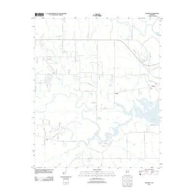
2012 Map of Waverly
USGS Topo · Published 2012About this map
The Tombigbee River and its complex network of tributaries define this landscape at the eastern edge of Clay County, just before the turn of the decade. The area is dominated by the sprawling Columbus Lake and the winding course of Tibbee Cr, which feeds into the river system. This survey is particularly valuable for genealogists, as it documents several small family and community burial grounds including Pooles Cem, Lee Cem, Young Cem, and Pitchlynn Cem near the historic settlement of Waverly. Further inland, the small community of Stephen sits at the junction of Decker Rd and Spring Cr. The land shows a transition from the structured plots of the Barton Ferry Rd corridor to the more water-dominated terrain near Red Bluff, illustrating the persistent influence of the river basin on local settlement and geography.
Find a feature on this map
73 named features on this map. Tap any name to fly to it.
Don’t see what you’re looking for? This feature index may not catch every label — zoom into the map to look around manually.
Map Details
Editions of this 2012 Waverly Map
This is the sole edition of this map. No revisions or reprints were ever made.
Other maps of this area

1953 · West Point
USGS Topo · 1:250,000

1958 · West Point
USGS Topo · 1:250,000

1959 · Artesia
USGS Topo · 1:62,500

1959 · West Point
USGS Topo · 1:62,500

1960 · Caledonia
USGS Topo · 1:62,500

1960 · Columbus
USGS Topo · 1:62,500

1963 · West Point
USGS Topo · 1:250,000

1982 · West Point
USGS Topo · 1:100,000

1984 · West Point
USGS Topo · 1:250,000
1987 · Hamilton
USGS Topo · 1:24,000