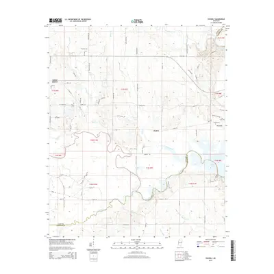
2015 Map of Waverly
USGS Topo · Published 2015About this map
Waverly Mansion stands as a primary cultural landmark on this survey of the Lowndes and Clay County border. The terrain is defined by the convergence of major waterways, where the Tombigbee River meets Tibbee Creek and feeds into Columbus Lake. This hydrological network has historically shaped the settlement patterns of the region, from the southeastern corner near Red Bluff to the eastern outskirts of West Point. Family history and local heritage are preserved in numerous small burial grounds, including Pooles Cem and Young Cem, which are scattered among the drainage basins of McGee Cr and Catalpa Creek. The map documents a landscape of rural roads and creek bottoms, reflecting the enduring agricultural and river-based character of the Waverly area.
Find a feature on this map
90 named features on this map. Tap any name to fly to it.
Don’t see what you’re looking for? This feature index may not catch every label — zoom into the map to look around manually.
Map Details
Editions of this 2015 Waverly Map
This is the sole edition of this map. No revisions or reprints were ever made.
Other maps of this area

1953 · West Point
USGS Topo · 1:250,000

1958 · West Point
USGS Topo · 1:250,000

1959 · Artesia
USGS Topo · 1:62,500

1959 · West Point
USGS Topo · 1:62,500

1960 · Caledonia
USGS Topo · 1:62,500

1960 · Columbus
USGS Topo · 1:62,500

1963 · West Point
USGS Topo · 1:250,000

1982 · West Point
USGS Topo · 1:100,000

1984 · West Point
USGS Topo · 1:250,000
1987 · Hamilton
USGS Topo · 1:24,000