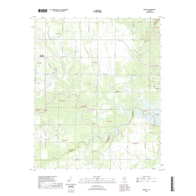
2018 Map of Waverly
USGS Topo · Published 2018About this map
Waverly and the surrounding river bottoms of the Tombigbee River define this part of the Clay and Lowndes County line. The settlement pattern is largely shaped by the meandering courses of Tibbee Creek and Catalpa Creek, which feed into the larger river system and its modern impoundments like Columbus Lake. Genealogists will find several small family or community burial grounds scattered across the landscape, including Pooles Cem, Lee Cem, and Pitchlynn Cem. These small cemeteries are often located near old roads like Old Waverly Rd and Old Hwy 50, tracing the history of the local families who settled along these waterways. The eastern edge of the map features a significant bend in the river near Kennedy Lake and the distinctive Red Bluff, while the western boundary reaches the outskirts of West Point.
Find a feature on this map
86 named features on this map. Tap any name to fly to it.
Don’t see what you’re looking for? This feature index may not catch every label — zoom into the map to look around manually.
Map Details
Editions of this 2018 Waverly Map
This is the sole edition of this map. No revisions or reprints were ever made.
Other maps of this area

1953 · West Point
USGS Topo · 1:250,000

1958 · West Point
USGS Topo · 1:250,000

1959 · Artesia
USGS Topo · 1:62,500

1959 · West Point
USGS Topo · 1:62,500

1960 · Caledonia
USGS Topo · 1:62,500

1960 · Columbus
USGS Topo · 1:62,500

1963 · West Point
USGS Topo · 1:250,000

1982 · West Point
USGS Topo · 1:100,000

1984 · West Point
USGS Topo · 1:250,000
1987 · Hamilton
USGS Topo · 1:24,000