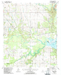
1987 Map of Waverly
USGS Topo · Published 1987About this map
Tibbee Creek and its complex network of tributaries, including Town Creek and Spring Creek, define the landscape near the Clay and Lowndes county line. The settlement of Waverly sits near the eastern edge of the survey, positioned north of the expansive Columbus Lake. This area reflects a deep-rooted rural community characterized by numerous localized houses of worship and burial grounds, such as St Johns Ch, Union Chapel, and the Tibbee Cem.
Find a feature on this map
39 named features on this map. Tap any name to fly to it.
Don’t see what you’re looking for? This feature index may not catch every label — zoom into the map to look around manually.
Map Details
Editions of this 1987 Waverly Map
This is the sole edition of this map. No revisions or reprints were ever made.
Other maps of this area

1953 · West Point
USGS Topo · 1:250,000

1958 · West Point
USGS Topo · 1:250,000

1959 · Artesia
USGS Topo · 1:62,500

1959 · West Point
USGS Topo · 1:62,500

1960 · Caledonia
USGS Topo · 1:62,500

1960 · Columbus
USGS Topo · 1:62,500

1963 · West Point
USGS Topo · 1:250,000

1982 · West Point
USGS Topo · 1:100,000

1984 · West Point
USGS Topo · 1:250,000
1987 · Hamilton
USGS Topo · 1:24,000