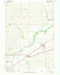
1964 Map of Waverly
USGS Topo · Published 1973About this map
Waverly stands as the primary hub in this mid-century survey of eastern Nebraska, situated at the intersection of a developing modern infrastructure and an older agricultural landscape. The town is tied to the region by the Burlington Northern railroad and Interstate 80, reflecting a period of transition as transportation networks expanded across the plains. The surrounding countryside is defined by the winding course of Salt Creek and its many tributaries, including Jordan Creek and Millville Creek, which carve through the distinct elevations of North Bluff and Rock Creek. Local history is anchored by rural landmarks such as Bethlehem Ch to the north and the Marian Center and Pierce Cem to the south. These markers of community life, alongside various survey points like the Tower and Substation, provide a clear picture of the land use patterns in Lancaster County during the early 1960s and 1970s.
Find a feature on this map
21 named features on this map. Tap any name to fly to it.
Don’t see what you’re looking for? This feature index may not catch every label — zoom into the map to look around manually.
Map Details
Editions of this 1964 Waverly Map
2 editions found

Other maps of this area

1893 · Fremont
USGS Topo · 1:125,000

1896 · Fremont
USGS Topo · 1:125,000

1897 · Lincoln
USGS Topo · 1:125,000

1899 · Wahoo
USGS Topo · 1:125,000

1903 · Weeping Water
USGS Topo · 1:125,000

1929 · Weeping Water
USGS Topo · 1:125,000

1955 · Fremont
USGS Topo · 1:250,000

1955 · Lincoln
USGS Topo · 1:250,000

1957 · Fremont
USGS Topo · 1:250,000

1957 · Lincoln
USGS Topo · 1:250,000