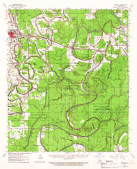
1961 Map of Waverly
USGS Topo · Published 1966About this map
Meandering bayous and an intensive logging economy define this corner of Northeast Louisiana in the early 1960s. The landscape is dominated by the sprawling Chicago Mill and Lumber Co Game Refuge and Preserve, which occupies much of the territory between the Tensas River and Bayou Macon. This area shows a complex network of waterways like Bull Calf Bayou and Roundaway Bayou, interspersed with remnants of industrial history such as several sections of Dismantled Railroad used for timber extraction.
Find a feature on this map
49 named features on this map. Tap any name to fly to it.
Don’t see what you’re looking for? This feature index may not catch every label — zoom into the map to look around manually.
Map Details
Editions of this 1961 Waverly Map
2 editions found

Other maps of this area

1909 · Tallulah
USGS Topo · 1:24,000

1935 · Winnsboro
USGS Topo · 1:62,500

1935 · Baskinton
USGS Topo · 1:62,500

1935 · Hurricane
USGS Topo · 1:62,500

1935 · Waverly
USGS Topo · 1:62,500

1935 · Shackleford Lake
USGS Topo · 1:62,500

1939 · Talla Bena
USGS Topo · 1:62,500

1939 · Alsatia
USGS Topo · 1:62,500

1955 · Jackson
USGS Topo · 1:250,000

1958 · Baskinton
USGS Topo · 1:62,500