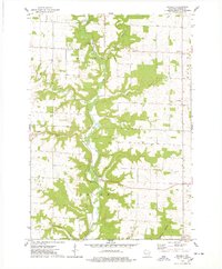
1974 Map of Waverly
USGS Topo · Published 1978About this map
Rush River carves a central path through this mid-1970s landscape, flanked by the township boundaries of El Paso, Rock Elm, Salem, and Union. The settlement pattern is characterized by small, dispersed rural nodes including Waverly, Ono, and Bremenington, the latter situated near the winding Morgan Coulee. This survey reveals a landscape balanced between agricultural use and local resource extraction, as evidenced by several marked quarries and a sandpit.
Find a feature on this map
17 named features on this map. Tap any name to fly to it.
Don’t see what you’re looking for? This feature index may not catch every label — zoom into the map to look around manually.
Map Details
Editions of this 1974 Waverly Map
This is the sole edition of this map. No revisions or reprints were ever made.
Other maps of this area

1935 · Arkansaw
USGS Topo · 1:48,000

1940 · Maiden Rock
USGS Topo · 1:62,500

1941 · Arkansaw
USGS Topo · 1:62,500

1942 · Arkansaw
USGS Topo · 1:62,500

1946 · Knapp
USGS Topo · 1:62,500

1949 · Knapp
USGS Topo · 1:62,500

1949 · Baldwin
USGS Topo · 1:62,500

1950 · Maiden Rock
USGS Topo · 1:62,500

1953 · Saint Paul
USGS Topo · 1:250,000

1959 · Saint Paul
USGS Topo · 1:250,000