
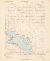
1951 Map of Wawasee
USGS Topo · Published 1951About this map
Lake Wawasee and Syracuse Lake anchor this 1951 topographic study of northern Indiana's lake country, showing a landscape defined by seasonal recreation and established agricultural crossroads. The town of Syracuse sits between the two major water bodies, served by the Baltimore and Ohio railroad which skirts the northern shore of the larger lake. Lakeside development is evident at Vawter Park and Oakwood Park, while landmarks like the Wawasee Fish Hatchery and several golf courses including Maxwelton Golf Club indicate the area's mid-century role as a regional destination.
Find a feature on this map
53 named features on this map. Tap any name to fly to it.
Don’t see what you’re looking for? This feature index may not catch every label — zoom into the map to look around manually.
Map Details
Editions of this 1951 Wawasee Map
2 editions found
Other maps of this area

1950 · Leesburg
USGS Topo · 1:24,000

1950 · North Webster
USGS Topo · 1:24,000

1951 · Milford
USGS Topo · 1:24,000

1951 · Ormas
USGS Topo · 1:24,000

1953 · Fort Wayne
USGS Topo · 1:250,000

1956 · Fort Wayne
USGS Topo · 1:250,000

1956 · Ligonier
USGS Topo · 1:24,000

1959 · Topeka
USGS Topo · 1:24,000

1959 · Millersburg
USGS Topo · 1:24,000

1959 · Goshen
USGS Topo · 1:24,000