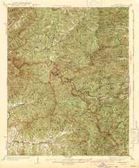
1942 Map of Wayah Bald
USGS Topo · Published 1942About this map
Wayah Bald and the surrounding high ridges of the Nantahala Mountains dominate this 1942 edition, which reflects the landscape as it appeared during the mid-1930s surveys. The terrain is defined by a series of prominent peaks, including Wine Spring Bald and Copper Bald, while the human footprint is concentrated in the deep valleys. The settlement of Rainbow Springs sits along the upper reaches of the Nantahala River, while the southern portion of the map follows the winding course of Shooting Creek.
Find a feature on this map
132 named features on this map. Tap any name to fly to it.
Don’t see what you’re looking for? This feature index may not catch every label — zoom into the map to look around manually.
Map Details
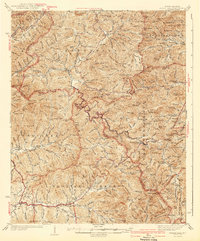
Editions of this 1942 Wayah Bald Map
2 editions found
Other maps of this area

1886 · Dahlonega
USGS Topo · 1:125,000

1886 · Walhalla
USGS Topo · 1:125,000

1891 · Cowee
USGS Topo · 1:125,000

1892 · Dahlonega
USGS Topo · 1:125,000

1892 · Walhalla
USGS Topo · 1:125,000

1896 · Walhalla
USGS Topo · 1:125,000

1896 · Dahlonega
USGS Topo · 1:125,000

1897 · Cowee
USGS Topo · 1:125,000

1903 · Dahlonega
USGS Topo · 1:125,000

1907 · Cowee
USGS Topo · 1:125,000