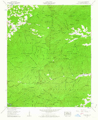
1957 Map of Wayah Bald
USGS Topo · Published 1963About this map
Wayah Bald and the high ridges of the Nantahala National Forest define this 1957 survey of Macon County, North Carolina. The legendary Appalachian Trail winds across the landscape, passing through high-elevation landmarks such as Wayah Crest Camp Ground and the Wilson Lick Ranger Station. This era shows a community deeply connected to its mountain topography, with small settlements like Kyle and Whiteoak Flats established along the watercourses.
Find a feature on this map
102 named features on this map. Tap any name to fly to it.
Don’t see what you’re looking for? This feature index may not catch every label — zoom into the map to look around manually.
Map Details
Editions of this 1957 Wayah Bald Map
4 editions found

Other maps of this area

1891 · Cowee
USGS Topo · 1:125,000

1897 · Cowee
USGS Topo · 1:125,000

1907 · Cowee
USGS Topo · 1:125,000

1933 · Bryson
USGS Topo · 1:62,500

1933 · Bushnell
USGS Topo · 1:62,500

1935 · Franklin
USGS Topo · 1:24,000

1935 · Rainbow Springs
USGS Topo · 1:24,000

1935 · Prentiss
USGS Topo · 1:24,000

1935 · Shooting Creek
USGS Topo · 1:24,000

1935 · Burningtown Bald
USGS Topo · 1:24,000