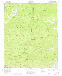
1957 Map of Wayah Bald
USGS Topo · Published 1979About this map
Nantahala National Forest dominates this topographic survey of the Blue Ridge, where the Appalachian Trail winds past high summits like Wayah Bald and Wine Spring Bald. The landscape is a network of named coves and ridges, reflecting a mid-century period when remote mountain sites like the Wilson Lick Ranger Station and Wayah Depot were active hubs for forest management and local commerce. Along the northern and eastern slopes, the settlement of Kyle and the presence of Whiteoak Flats Church and Mt Sinai Church indicate established rural communities sustained by the surrounding drainages of Burningtown Creek and Otter Creek. Evidence of earlier industrial activity remains in the mountain gaps, including the Abandoned Mica Mine and Corundum No 1, highlighting the region's history of mineral extraction within the deep hollows of the Nantahala Mountains.
Find a feature on this map
108 named features on this map. Tap any name to fly to it.
Don’t see what you’re looking for? This feature index may not catch every label — zoom into the map to look around manually.
Map Details
Editions of this 1957 Wayah Bald Map
4 editions found

Other maps of this area

1891 · Cowee
USGS Topo · 1:125,000

1897 · Cowee
USGS Topo · 1:125,000

1907 · Cowee
USGS Topo · 1:125,000

1933 · Bryson
USGS Topo · 1:62,500

1933 · Bushnell
USGS Topo · 1:62,500

1935 · Franklin
USGS Topo · 1:24,000

1935 · Rainbow Springs
USGS Topo · 1:24,000

1935 · Prentiss
USGS Topo · 1:24,000

1935 · Shooting Creek
USGS Topo · 1:24,000

1935 · Burningtown Bald
USGS Topo · 1:24,000