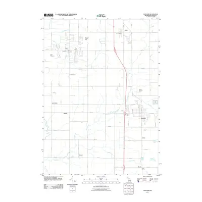
2011 Map of Wayland
USGS Topo · Published 2011About this map
Wayland and the surrounding townships in Allegan County are defined by a grid of agricultural land and the meandering paths of the Rabbit River and its tributaries. The landscape in this 2011 survey is anchored by several distinct settlements along the north-south corridor, including Dorr, Moline, and Bradley. A collection of historic burial grounds provides valuable genealogical data, such as Saint Stanislaus' Catholic Cemetery near Hilliards and Elmwood Cemetery to the south. Local aviation is represented by the Wayland Municipal Airport and the Senneker Landing Strip, reflecting the region's flat geography and rural infrastructure. The waterway network, featuring Buskirk Creek, Red Run, and Little Rabbit River, underscores the importance of drainage and irrigation for the productive farmlands that span between the primary north-south thoroughfares. Researching families will find specific neighborhood locations like the Hungry Horse Campground and local post offices in each primary village center.
Find a feature on this map
64 named features on this map. Tap any name to fly to it.
Don’t see what you’re looking for? This feature index may not catch every label — zoom into the map to look around manually.
Map Details
Editions of this 2011 Wayland Map
This is the sole edition of this map. No revisions or reprints were ever made.
Other maps of this area

1914 · Grand Rapids
USGS Topo · 1:62,500

1943 · Grand Rapids
USGS Topo · 1:62,500

1958 · Allegan
USGS Topo · 1:62,500

1958 · Grandville
USGS Topo · 1:62,500

1958 · Grand Rapids
USGS Topo · 1:250,000

1959 · Wayland
USGS Topo · 1:62,500

1961 · Grand Rapids
USGS Topo · 1:250,000

1962 · Grand Rapids
USGS Topo · 1:250,000
1967 · Cutlerville
USGS Topo · 1:24,000
1967 · Caledonia
USGS Topo · 1:24,000