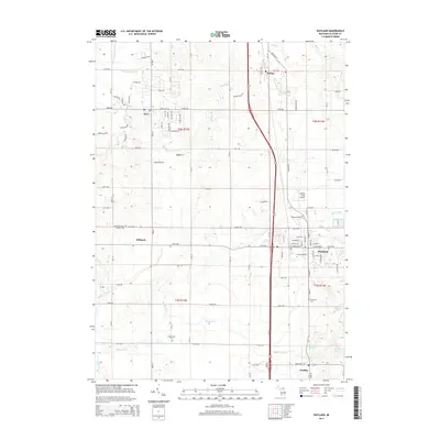
2014 Map of Wayland
USGS Topo · Published 2014About this map
The Rabbit River and its tributaries, including the Little Rabbit River and Buskirk Cr, carve a complex drainage system through this portion of Allegan County. The settlement of Wayland serves as a primary hub, with its grid of streets such as W Superior St and W Sycamore St well established. For those researching local families, the map identifies several burial grounds including Dorr Cem, Saint Stanislaus Catholic Cem, Elmwood Cem, and Maplewood Cem. Smaller hamlets like Moline, Dorr, and Hilliards are connected by a network of rural roads, including 142nd Ave and 18th St. The presence of Calkins Field Airport near Wayland and the proximity of several lakes like Doans Lake and McIntire Lake highlight the area's mix of aviation history and natural water features.
Find a feature on this map
54 named features on this map. Tap any name to fly to it.
Don’t see what you’re looking for? This feature index may not catch every label — zoom into the map to look around manually.
Map Details
Editions of this 2014 Wayland Map
This is the sole edition of this map. No revisions or reprints were ever made.
Other maps of this area

1914 · Grand Rapids
USGS Topo · 1:62,500

1943 · Grand Rapids
USGS Topo · 1:62,500

1958 · Allegan
USGS Topo · 1:62,500

1958 · Grandville
USGS Topo · 1:62,500

1958 · Grand Rapids
USGS Topo · 1:250,000

1959 · Wayland
USGS Topo · 1:62,500

1961 · Grand Rapids
USGS Topo · 1:250,000

1962 · Grand Rapids
USGS Topo · 1:250,000
1967 · Cutlerville
USGS Topo · 1:24,000
1967 · Caledonia
USGS Topo · 1:24,000