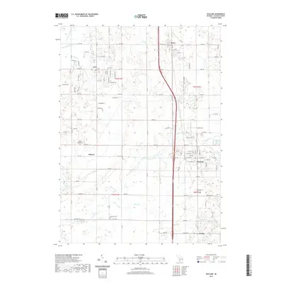
2019 Map of Wayland
USGS Topo · Published 2019About this map
The Rabbit River and its various tributaries, including the Little Rabbit River, Buskirk Creek, and Red Run, define the hydrology of this rural Allegan County landscape. The area is anchored by the established settlements of Wayland and Dorr, with smaller clusters at Moline, Hilliards, and Bradley. These communities are connected by a grid of agricultural section roads and the prominent north-south corridor of US Highway 131. A high concentration of local burial grounds, such as Saint Stanislaus Catholic Cemetery, Dorr Cemetery, Elmwood Cemetery, and Maplewood Cemetery, provides a wealth of data for genealogists tracing family histories in the township. Further east, the terrain becomes more varied with small glacial kettle lakes like McIntire Lake, Titus Lake, and Doans Lake, while Calkins Field indicates localized aviation activity.
Find a feature on this map
58 named features on this map. Tap any name to fly to it.
Don’t see what you’re looking for? This feature index may not catch every label — zoom into the map to look around manually.
Map Details
Editions of this 2019 Wayland Map
This is the sole edition of this map. No revisions or reprints were ever made.
Other maps of this area

1914 · Grand Rapids
USGS Topo · 1:62,500

1943 · Grand Rapids
USGS Topo · 1:62,500

1958 · Allegan
USGS Topo · 1:62,500

1958 · Grandville
USGS Topo · 1:62,500

1958 · Grand Rapids
USGS Topo · 1:250,000

1959 · Wayland
USGS Topo · 1:62,500

1961 · Grand Rapids
USGS Topo · 1:250,000

1962 · Grand Rapids
USGS Topo · 1:250,000
1967 · Cutlerville
USGS Topo · 1:24,000
1967 · Caledonia
USGS Topo · 1:24,000