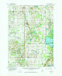
1959 Map of Wayland
USGS Topo · Published 1973About this map
Wayland sits at the heart of this late-1950s landscape, serving as a primary hub where the Pennsylvania railroad and the Central highway corridor converge. The geography is defined by a dense network of glacial kettle lakes and wetlands, particularly concentrated in the eastern portion within the Yankee Springs Recreation Area. This region is characterized by an intricate mix of rural industry and community infrastructure, evidenced by numerous Gravel Pits and family-named landmarks like Bowens Mill.
Find a feature on this map
112 named features on this map. Tap any name to fly to it.
Don’t see what you’re looking for? This feature index may not catch every label — zoom into the map to look around manually.
Map Details
Editions of this 1959 Wayland Map
2 editions found

Other maps of this area

1914 · Grand Rapids
USGS Topo · 1:62,500

1916 · Kalamazoo
USGS Topo · 1:62,500

1918 · Kalamazoo
USGS Topo · 1:62,500

1918 · Galesburg
USGS Topo · 1:62,500

1918 · Lowell
USGS Topo · 1:62,500

1943 · Kalamazoo
USGS Topo · 1:62,500

1943 · Grand Rapids
USGS Topo · 1:62,500

1943 · Lowell
USGS Topo · 1:62,500

1944 · Galesburg
USGS Topo · 1:62,500

1946 · Gobles
USGS Topo · 1:62,500