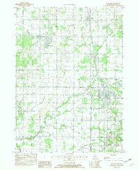
1982 Map of Wayland
USGS Topo · Published 1982About this map
Wayland and the surrounding townships of Dorr, Leighton, Hopkins, and Wayland reflect a rural Michigan landscape defined by a grid of agricultural section lines and the winding course of the Rabbit River. The map documents a cluster of settlements and institutional centers, from the larger hub at Wayland to the smaller hamlets of Moline, Hilliards, and Bradley. Local genealogy is well-served by the presence of several community anchors, including St Stanislaus Sch and its adjacent St Stanislaus Cem, as well as Sproat Cem and Maplewood Cem. The Conrail line runs north-to-south through the terrain, paralleled by drainage networks like Fales Drain and Haney Drain, which were essential for managing the low-lying lands near Green Lake and McIntyre Lake. A small private aviation point, the Senneker Landing Strip, sits north of the Dorr town site.
Find a feature on this map
42 named features on this map. Tap any name to fly to it.
Don’t see what you’re looking for? This feature index may not catch every label — zoom into the map to look around manually.
Map Details
Editions of this 1982 Wayland Map
This is the sole edition of this map. No revisions or reprints were ever made.
Other maps of this area

1914 · Grand Rapids
USGS Topo · 1:62,500

1943 · Grand Rapids
USGS Topo · 1:62,500

1958 · Allegan
USGS Topo · 1:62,500

1958 · Grandville
USGS Topo · 1:62,500

1958 · Grand Rapids
USGS Topo · 1:250,000

1959 · Wayland
USGS Topo · 1:62,500

1961 · Grand Rapids
USGS Topo · 1:250,000

1962 · Grand Rapids
USGS Topo · 1:250,000
1967 · Cutlerville
USGS Topo · 1:24,000
1967 · Caledonia
USGS Topo · 1:24,000